www.BadgerTrek.comAbout/ContactWeb LogOur Camper Van
Resources:Hobbies:MotorcyclesAmy's CakesOutboard Hydroplane RacingRadio Controlled Toys |
We are now in Death Valley. Hard to believe that a few weeks ago we were living above the ocean with lush green plants all about, and now we are surrounded by rocks, sand, and have to hunt for the rare plant.
In the past few weeks we have encountered temperatures from -6f to 75, and spent an entire week below freezing with nights below 0 (thus with nightly freezing of our water lines). The insulation we have added in the past year has made the experience more pleasant than last year however, with the insulation under the carpet probably contributing the greatest.
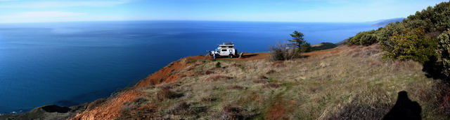
Anyway, to go chronologically, we started out on the bluff above the Pacific Ocean. The camping spot, as described before, had an awesome view, and was at the end of a steep rutty 4x4 trail, so we only saw 3 vehicles come by in the 11 days we spent up there. At the end of this period we were finding that although we could have stayed longer (2 more day's of water), we would be getting some pretty bland food for those days. We decided to begin our movement again.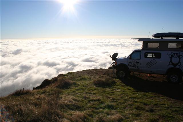
Since we were finding ourselves quite low on a lot of food staples, as well as needing some hardware for bracing the new bike-rack on the rear bumper box, we thought we would head back through Santa Cruz, say one last good-by to Shane and Laurie, treat them to dinner in thanks for their hospitality, and then head east.
On the way north to Santa Cruz we ran across a surplus shop and picked up a couple of used 5 gallon Scepter water cans. With our average daily usage of water working out to about 2 gallons, this increased our carried water to about 15 days with a bit of reserve.
After our stop in Santa Cruz, with the largest grocery bill we have ever had (we had been gradually working our way through most of the reserves in the van over the last few months, and had not been replacing as fast until we felt we knew what we actually used, and what we did not).
From Santa Cruz we headed east (and a bit north to the first open pass through the mountains) and ended up above Mono Lake in eastern California. As we approached the lake we found a dirt-track heading into some very interesting rock formations, so we turned in there and found our way to a lovely camping spot between a few grand rock sculptures, with an otherworldly view of countless other jutting rocks, and the steaming lake in the distance (The temperature was about 10f when we stopped, and the lake was much warmer). 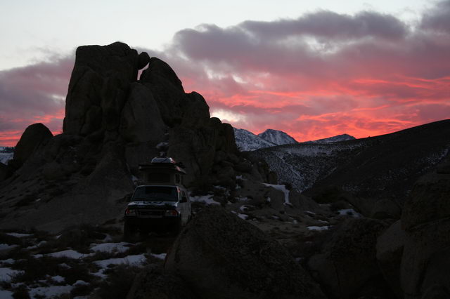
The temperature continued to drop over the next couple days, while we hiked around and explored the local hills, mines, and rocks. In the news there was much fretting about the cold snap in the California central valley killing citrus crops, while we were getting nightly lows about -5f, and daily highs in the teens. Each morning we would find our water lines frozen (likely where they cross above the rear door, not much room for insulation there), even when we left the furnace on at low all night. The temperature in the cabin was comfortable even with the top up down to about 0f outside, much better than last year, probably because of the insulation we have been adding in various places. A number of the days included high winds, with gusts to about 70, and forced us to hunker down while the snow and sand blew about. We even saw a violent looking water-spout form above Mono Lake that must have reached 1000' in seconds, before dissipating a minute later. 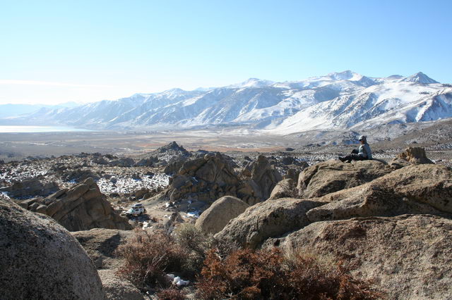
A bit less than a week of hiding in the rocks and we felt the itch to move on. Since we had been looking at Mono lake in the binoculars, we had seen the strange rocks sticking partially out of the lake and decided to investigate. The rocks turned out to be mineral deposits from numerous sub-surface springs which were exposed when water was diverted from the lake to quench the thirst of the LA area. A little lake-front walk provided an up-close look at the formations, called Tufa. 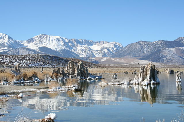
From Mono Lake we continued south to Bishop, CA in the Owens valley. We stopped for supplies, fuel, and coffee at a book-shop for a bit of civilization. Before it became too late we headed south and east on the Death Valley road, looking for a good place to setup house. We chose to go a few miles down the Saline Valley road, and then followed a wash about a mile up before finding a secluded spot for the night.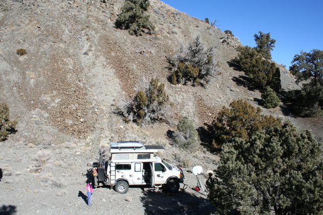
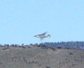
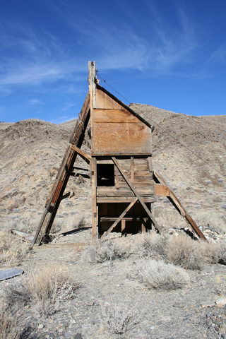
| The next day we had a better view of our surroundings, having arrived after sunset the evening prior, and found the warmth, lack of wind, and ever branching washes and canyons tempting us to stay a while. We hiked around exploring the valleys, all of which seemed to have been used as roads long ago, with mine remnants nearly everywhere if you looked close enough. We found old open mine-shafts, rusted gold-pans, decayed sluice-boxes, and remains of old cabins. Every few hours a military fighter or two would fly right overhead, perhaps 2-300 feet above the hill tops. |
 |
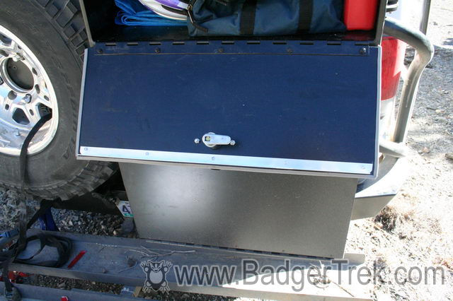
On one of the warmer days I spent a couple hours installing some angle-aluminum in the doors and shelving of the rear bumper box to reduce the flexing it experienced, and reinforce the bike-mounts on the top. I had found that the shelf in the box was not attached at the rear of the box, and drooped about 1/2" with the load on it, while the doors were only flat sheets of aluminum, so the corners would bow out when things inside shifted and placed pressure on them.
 |
Once we were feeling cramped in the canyon, and longing for a wider view, we chose to spend a day for a return to Bishop to do laundry, top-up, make some phone calls, and then head down into Saline Valley, a part of the Death Valley National Monument, past many old mine relics in amazingly well preserved condition. |
The first night we made it a ways along the road towards Saline Valley, part of Death Valley National Monument, and camped just off the roadside in a wide canyon. The next morning we continued on, passing through some relatively high forested areas before descending into the barren Saline Valley. At the bottom of the wide valley we followed a track that lead to 3 hot-springs. The first two were fairly well developed, with concrete pools, showers, and numerous campers. The third was pretty much un-developed, a couple miles out on a 4x4 track through the boulders of the valley floor, and had no one near it. This of-course, is were we stopped. 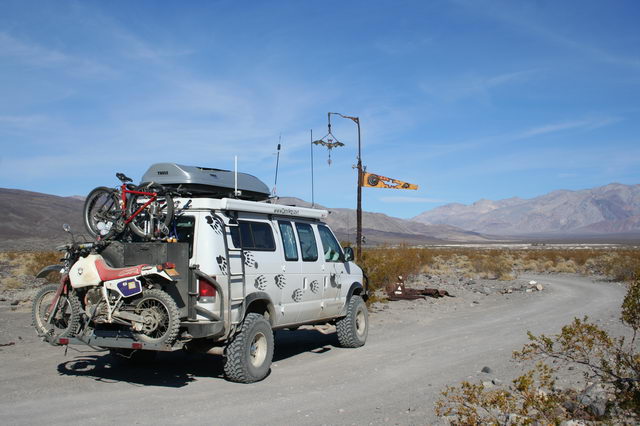
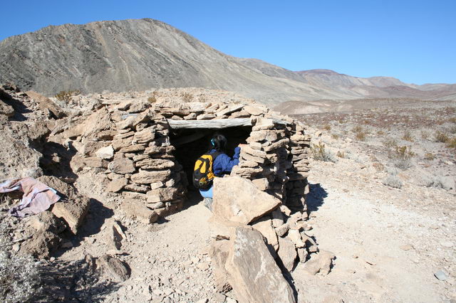
| Here, again, we stayed for a number of days. The first day we hiked around the nearby valley, finding a number of small cold-springs frequented by the local burros, an ancient stone shelter, and just enjoying the stark environment. Even some volcanic lava tubes and other remnants were visible in the area. | 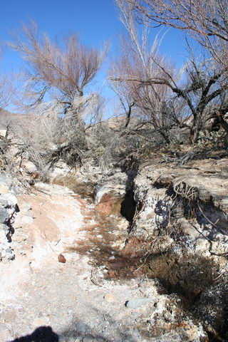 |
A couple days later we hiked back to the other hot-springs to see what facilities they actually provided. On closer inspection they did not look terribly attractive, and the first one we had seen no-longer even had much flowing water in the springs due to natural variations in the springs' outputs. On our return we found one of the local burros had come to visit our van, so we tossed him an apple and said hello. 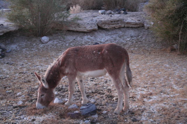
| Our spring, however, was a nice comfortable 95f, with stone benches, and no real mineral smells. Pretty much just a hot bath-tub. We dipped in once, and used the water to break in some of our water-purification equipment we had not had a chance to use. | 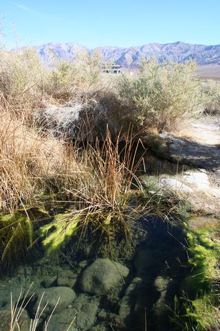 |
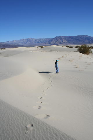 |
Once the novelty of camping by our own little spring was getting old, we decided to continue through the Saline Valley to see the Saline Dunes and Saline Lake before taking a more-difficult 4x4 trail that was listed in one of our books. The dunes were interesting to walk around in, though not terribly extensive, and the lake was nearly dry, and seemingly inaccessible due to a "wildlife reserve" fence all around when the road was near. |
| A few miles past the lake we turned east on the 4x4 trail listed in our book. This trail leads from the Saline valley road up a narrow gully, ascending a few thousand feet in about 3 miles, to the Lippencott mine at the south end of the famous Racetrack Playa with the "sailing stones". The trail was one of the more interesting we have taken recently, with large boulders in the track, and some very narrow switch-backs that were partially washed-out. The new larger tires certainly made the journey much more comfortable than it would have been with the original set. | 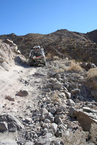 |
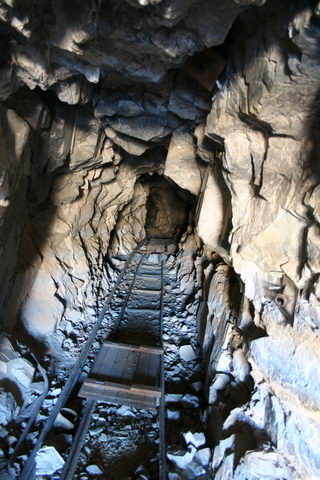 |
Lippencott Mine turned out to be a number of holes in a mountain, with a few remnants of cart tracks and sorted rock piles. The opening to the mine tunnel was blockaded a few feet in, but the view inside was interesting, watching the cart tracks pass off into the darkness. We could see a few bats fluttering about back in the depths, but they didn't seem interested in coming out to say hello in the daylight. |
After investigating the mine area we chose a camping spot about 1/2 mile back down the 4x4 trail for some nice views over the Saline valley and privacy from traffic on the Racetrack road. The spot also yielded some views of mine tunnels from the nearby mine just opening into wide open space on the sheer sides of the mountain face.
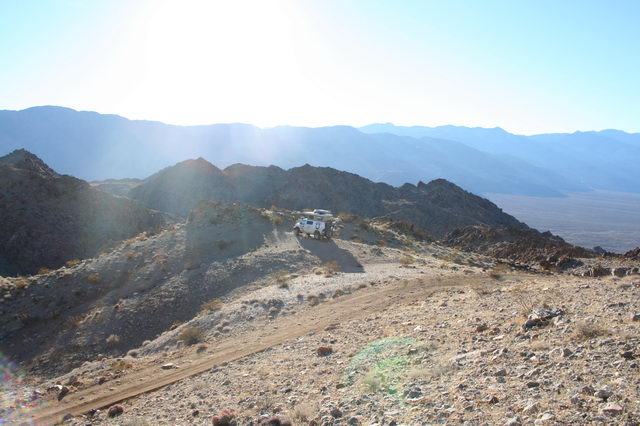
We did spend some time hiking about in the hills, climbing the ridge behind the van to a stunning view of the Saline valley on one side, and the Racetrack playa on the other.
Web Log Sections (Newest at Bottom):
- 06-2005 - Pickup the Van, First impressions, NYC Licensing Show
- 07-2005 - Work on the Van
- 08-2005 - Salt Lake City, Paragliding, & Work on the Van
- 09-2005 - Seattle, WA/OR Coast, to Magruder Corridor, & More Work on the Van
- 10-2005 - Western Montana, Wyoming, to Salt Lake City
- 11-2005 - City of Rocks, Mountain Home, ID, SLC
- 12-2005 - Moab, UT & Canyonlands NP
- 01-2006 to 02-2006 - Snowboarding and Seattle
- 03-2006 - Paris
- 04-2006 - Paris & London
- 05-2006 First Half - Paris
- 05-2006 Second Half - Southern France
- 06-2006 to 07-2006 - Return to the states and Yoga Center
- 08-2006 - Sportsmobile Rally, Colorado
- 09-2006 - End of Yoga, Bamf, Vermont, Boston, St Louis, Badlands
- 10-2006 - Work on Van (wheels, roof, wiring); Amy's version of last couple months
- 10-2006 Second Half - Amy's trip to Las Vegas; Great Basin NP
- 11-2006 - Nevada, Oregon, Motorcycle Race
- 12-2006 - Southern Oregon, California, Christmas, Aluminess Bumpers
- 01-2007 - Christmas w Shane & Laurie, Camping above Pacific Ocean
- 01-2007 - Pacific Ocean to Death Valley
- 02-2007 - Death Valley to Arizona
- 03-2007 - Zion NP, Grand Staircase NM, Bryce Canyon NP, Canyonlands NP
- 04-2007 - Utah through Arizona, Anasazi Ruins, Some tweaks to the van
- 01-2008 - Holiday trip through Northwest US
- 07-2008 - Spring and Summer 2008 (WiVi arrives!)
- 12-2009 - Camping Trip, Breakdown, and lots of Work on Van.
- Current